Washing Machine
Once a month I go east on Highway 20 to Tatla Lake. The principal reason is to attend the library book club. But on the way I visit the church. I am not a Christian, but the church community kindly lets me use the small washing machine installed in the bathroom for people with poor water supplies. There is no laundromat closer than a 3 hour drive. The Chilcotin is not an easy place to find good water and at one time the washing machine got a lot more use. I think I am the only person taking advantage of it now. It is small and slow – but what luxury! I save up all the big stuff: sheets; towels; workclothes. They also have huge sinks so I can soak large sweaters and other items I don’t want to risk in the machine.
Having left a load zunking around, I drove the extra couple of miles into downtown Tatla .
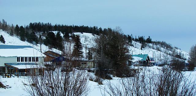
Tatla Lake

The building on the left is the hall; the lean-to porch covers the entrance to the library in the basement. (The white area in the foreground is a pond. The lake after which the community is named lies a little further east.) On the extreme far right is the Graham Inn, half hidden by the dark building with the teal roof – it used to be the ranchhouse, and it is quite a historic building for this area. The brown structure partially seen behind the library is the store and post office. The settlement also boasts a motel, a nursing station and a school. It is one of the smallest communities on the Chilcotin, despite servicing the area south which includes many residents on a number of lakes. The phone book is less than a page: this includes numbers belonging to short-term summer people as well as institutions such as police, poison control, hydro and so on, none of which have offices anywhere near the place. The school was built for about 60 kids, but at last count there were only 17. It would have been closed, but there is no other school for two hours in either direction.
White Saddle Air
I had arranged to meet one of the book club members at the Graham Inn for lunch. Jen King is 89; she drove herself along the half-hour stretch of icy roads from her home. She is the matriach of White Saddle Air. Just as she and her husband were planning to start the business, his helicopter crashed in the ocean. Against all odds, she decided to keep going. Her two sons and their wives run the company now, which includes accommodation for their guests. White Saddle will fly anywhere, but their main stamping ground is Mt Waddington; at around 13,000 feet it is the highest peak completely in BC. Right now they are extremely busy with heliskiers. A few years ago they hosted 3 movies, one of which was Seven Years In Tibet. Yes, Brad Pitt actually came to Tatla Lake!
A quick trip to the church so I could change the load in the machine and back to the library for the book club.
Tatla Lake Library

Jen is on the left of the picture; Jeannie, the librarian, is in the centre, and Christine is on the right. The club is usually just the four of us. We don’t have a set book to read – it takes too long to get enough copies in such a small place; we simply tell everyone about the things we have enjoyed – or not, as the case may be.
The Lure of the Chilcotin
Christine originated in New York and came out here with a partner to live the life of hippy trappers in the bush. Christine self-published The Lure of the Chilcotin – she recounts such crazy things it is a wonder that they did not kill themselves! Now she lives not far from Tatla but in a similar way to me – she heats and cooks with wood and has no running water etc, but her son has recently built a house nearby and drilled a well, so she can go over to his place to use the washing machine. (Christine has no email; if any of you are interested in her book, let me know.)
On the 40-minute drive to Tatla, I saw one vehicle. Coming back, during commuting time, I met 3 vehicles plus the plough truck. A real Chilcotin rush hour…
